Information experts harness rising flood of accessible water data
*Fourth interview in Aqua-Statisticians: A five part series

Marisha Wojciechowska-Shibuya: Given universal access to satellite technology and modeling software capacity available to everyone, what can the UN do that uniquely adds value?
Karen Frenken: New technologies improve the quantity and availability of water data. But AQUASTAT’s structure and experience helps organize and calibrate that data, ensures access to the data remains free, and makes use of remote sensing and performs modeling to fill up data gaps.
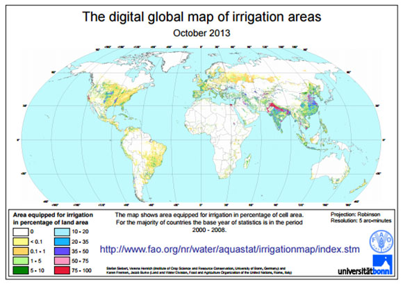
For example, we combine statistics, modeling and remote sensing in the latest global map of irrigation areas, developed in collaboration with the University of Bonn. In this case, sub-national irrigation statistics were combined with geospatial information on the position and extent of irrigation schemes (to compute the fraction of 5 arc minute cells that were equipped for irrigation), otherwise referred to as irrigation density.

We applied a global model to simulate consumptive water uses for irrigation by source of water (surface water, groundwater or non-conventional sources of water such as direct use of wastewater, agricultural drainage water and desalinated water). And this inventory now provides data for more than 15 000 national and sub-national administrative units.
A second valuable use of remote sensing lies in the assessment of water productivity gaps. By monitoring, and comparing current productivity levels in various agricultural systems, we can analyse what causes productivity gaps, and find ways to reduce them.
Breakthroughs in earth observation science allow us to extract key data on sustainable agricultural production, based on spatial satellite measurements. FAO in partnership with UNESCO-IHE Institute for Water and Education is applying this approach in a countries where AQUASTAT has provided the basic data.
In a third initiative, AQUASTAT has undertaken a modeling exercise for the years 2000 and 2005 that aims to assess industrial and municipal water withdrawals.
As for agricultural water withdrawals, statistical data on irrigated crops – collected during AQUASTAT country updates – make it possible to prepare a typical irrigated crop calendar, by country. Using a water balance model, AQUASTAT has thus undertaken a review of irrigation water requirement and irrigation water withdrawals.
Despite these advances, all remote sensing and modeling activities still rely on statistical data for their calibration. This endures as a central activity for AQUASTAT, on which researchers and modelers rely.
Indeed, the World Resources Institute’s “Aqueduct”, Microsoft’s “Water Stress” index, and the World Business Council for Sustainable Development’s “Global Water Tool” all use AQUASTAT and would struggle to launch or maintain these programmes without us.


