As a water engineer or water modeler, you know a hydraulic model enables you to evaluate the design of a system before it is built, or identify the optimal operation and renewal strategy. You may be using it for long-term planning so that expansion and rehabilitation decisions can be made in advance of population growth.
But are you happy with your current modeling solution? Is it enabling you to keep up with other advancing technologies, like the new ArcGIS Pro, or is it causing you headaches and holding you back?
Hydraulic modeling can be used as a reliable decision-support tool, across a wide range of projects, from the design of a new system and pipe replacement, to operation and emergency response, but only if it works properly with the other systems you’re using.
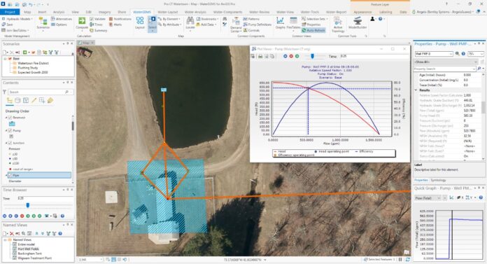
Integration of your hydraulic modeling software with the leading GIS platforms like the new ArcGIS Pro can streamline water network modeling. Continue reading or watch this webinar to see how OpenFlows WaterGEMS integrates within your ArcGIS Pro software. The new ArcGIS Pro integration is included with any WaterGEMS subscription, making a total of five platforms available to WaterGEMS users (the others are the stand-alone interface, MicroStation, AutoCAD and ArcMap). Does your current modeling software allow you to integrate with GIS and CAD platforms the way OpenFlows WaterGEMS does?
What Is OpenFlows WaterGEMS?
OpenFlows WaterGEMS is a hydraulic modeling application for water distribution systems with advanced interoperability, geospatial model building, optimization, and asset management capabilities. From fire flow and water quality analyses to energy consumption and capital cost management, WaterGEMS provides an easy-to-use environment for engineers to analyze, design, and optimize water distribution systems.
Using WaterGEMS in ArcGIS Pro
The integration of ArcGIS Pro and WaterGEMS allows you to seamlessly analyze and design your water distribution system leveraging the GIS capabilities such as advanced geographic maps in the native ArcGIS Pro functionality. From modeling to results to schematics, you can visualize everything in your GIS platform. The latest version of WaterGEMS can run within ArcGIS Pro, and this upgrade comes at no additional cost.
If you have ArcGIS Pro on your computer, when you install the latest version of WaterGEMS, it will automatically integrate with it.
The integration allows you to work on new or existing WaterGEMS models in ArcGIS. Once you add or create a hydraulic model to use in WaterGEMS for ArcGIS Pro, the workflow for adding and editing model elements and computing a model will be similar to working in WaterGEMS stand-alone.
Interoperability
The seamless interoperability of WaterGEMS with multiple platforms distinguishes Bentley from its competitors. ArcGIS Pro is only one of several available platforms. WaterGEMS integrates with other third-party solutions like AutoCAD and ArcMap, other Bentley solutions like MicroStation, or as a stand-alone product. There is no additional cost for any of these integrations with WaterGEMS; if you have WaterGEMS and the additional solution on your machine, you have everything you need for them to work together.
Six Reasons Engineers Prefer WaterGEMS
WaterGEMS provides many benefits beyond platform versatility. Here are six highlights:
1. It offers a friendly and intuitive interface, promoting a quick learning curve.
2. Support for multiple steady-state and extended period simulation scenarios makes WaterGEMS ideal for Master Planning. Use system growth analysis, new land use mapping, and operation strategy modeling to plan confidently.
3. WaterGEMS automates pressure zone identification and analysis. Users can easily define and visualize pressure zones to identify expected flow for each zone and its maximum and minimum values for pressure and hydraulic grade.
4. Identify logical district metered areas (DMAs) using WaterGEMS. As you assign a target number of nodes or total pipe length to define area size, the application will identify areas with minimal pipe closures/meters needed.
5. Water quality analysis is versatile and easy to configure. You can create simple water quality simulations for constituent (e.g., chlorine) concentration, water age, and source tracing, or use advanced tools for multispecies analysis (MSX) and water quality batch runs.
6. Connect your hydraulic model to SCADA signals to easily compare simulated results with field measurements when calibrating the model. Or, initialize the model from current system conditions to model Emergency Events such as a pipe break or pump shutdown.
Two Ways to Get Started with WaterGEMS in ArcGIS Pro
1. Import an existing WaterGEMS model into your ArcGIS Pro platform and get to work!
2. Create new WaterGEMS model within ArcGIS Pro:
a. Add your hydraulic model and specify your WaterGEMS file name.
b. Specify your coordinate system. If you don’t know the exact name of your coordinate system, you can use the import feature to automatically use the spatial reference of an existing feature layer.
c. Once this is done, the entire hydraulic model is going to get synchronized and will appear in your table of contents.
d. Now you have a blank hydraulic model to work on in ArcGIS Pro!
See It In Action
Watch our detailed on-demand webinar. Discover How to Model Your Water System in ArcGIS Pro with Bentley water expert, Kristen Dietrich, to learn more and see this integration in action. Topics include:
• Creating projects
• Accessing model element layout tools
• Performing model building and load allocation from GIS data sources
• Connecting ArcGIS Pro attribute tables with WaterGEMS geotables
• Customizing element symbols
• Visualizing results with color coding and annotation
• Working with multiple scenarios (including Active Topology display)


